Return
- Products and Services
- Proprietary technology empowers businesses and services.
SenseFoundry Enterprise Applications
Geospatial Analytics
Product Description
We are dedicated to the development of AI-powered geospatial technology and products that span from R&D to real-world applications. Based on SenseTime's vision foundation model and years of dedicated research and development in geospatial technology, we have launched our remote sensing foundation model, which incorporates more than 350 million parameters. It has more than 46 types of semantic segmentation capabilities, covering algorithms in land use classification, change detection, object detection, and super-resolution. SenseTime's AI-powered geospatial analytics products are now serving more than 20,000 clients across various industries worldwide.

Series Products
Product Highlights
-
 Cutting-edge AI-powered geospatial analytics capabilitiesBased on SenseTime's powerful large-scale vision foundation model, our algorithms demonstrate high generalization ability across different sensors, seasons, regions and terrains. Our industry-leading semantic segmentation algorithms consistently deliver results comparable to human annotations.
 -
 A wide range of algorithms to meet diverse business needsOur platform offers a wide range of algorithms tailored to address various business requirements. These algorithms were trained by our massive multi-industry datasets, enabling substantial cost reduction and efficiency improvement for our customers.
-
 Multiple services for different scenariosWe offer a comprehensive suite of products and services, including a data annotation platform, AI algorithm training services, visualized machine learning platform, etc. to cater to the diverse needs of our customers.
Application Scenarios
- 01
- 02
- 03
- 04
- 05
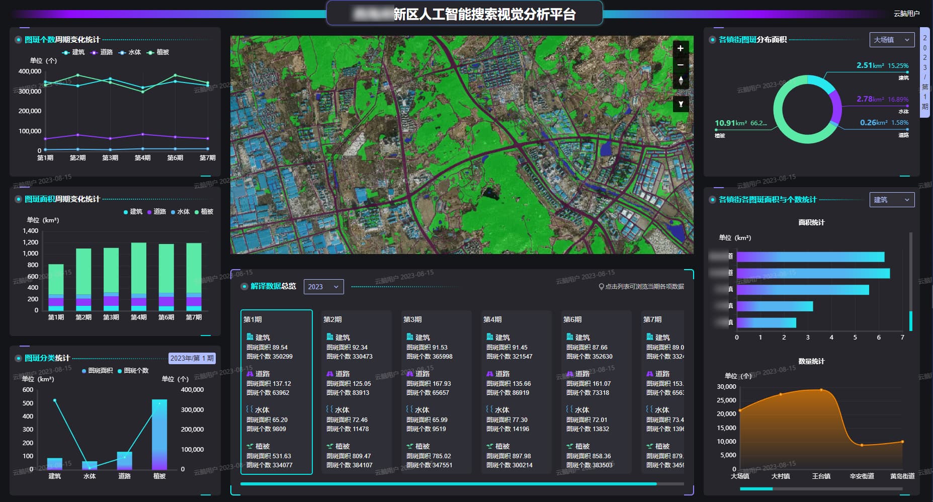
Land Use Monitoring
By analyzing high-frequency satellite images, we are able to produce professional data analytics and provide unified map services and spatial analysis API. This empowers local government agencies with reliable data sources for effective management, planning, and decision-making.
By analyzing high-frequency satellite images, we are able to produce professional data analytics and provide unified map services and spatial analysis API. This empowers local government agencies with reliable data sources for effective management, planning, and decision-making.
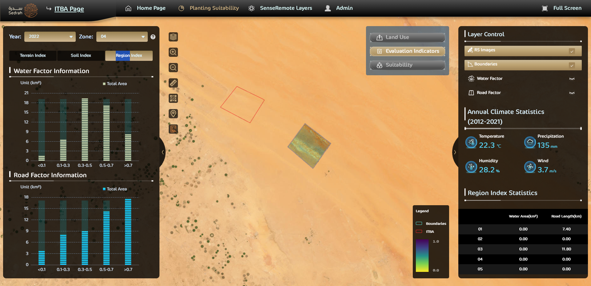
Ecological Monitoring of Natural Reserves【Sedrah MVP Platform】
In 2022, we launched ecological monitoring services for Saudi Arabia's ITBA Royal Nature Reserve. We established suitability evaluation metrics and algorithms for specific plants to guide vegetation planting and growth. Our technology played a key role in monitoring and protecting the ecological environment of the natural reserve.
In 2022, we launched ecological monitoring services for Saudi Arabia's ITBA Royal Nature Reserve. We established suitability evaluation metrics and algorithms for specific plants to guide vegetation planting and growth. Our technology played a key role in monitoring and protecting the ecological environment of the natural reserve.
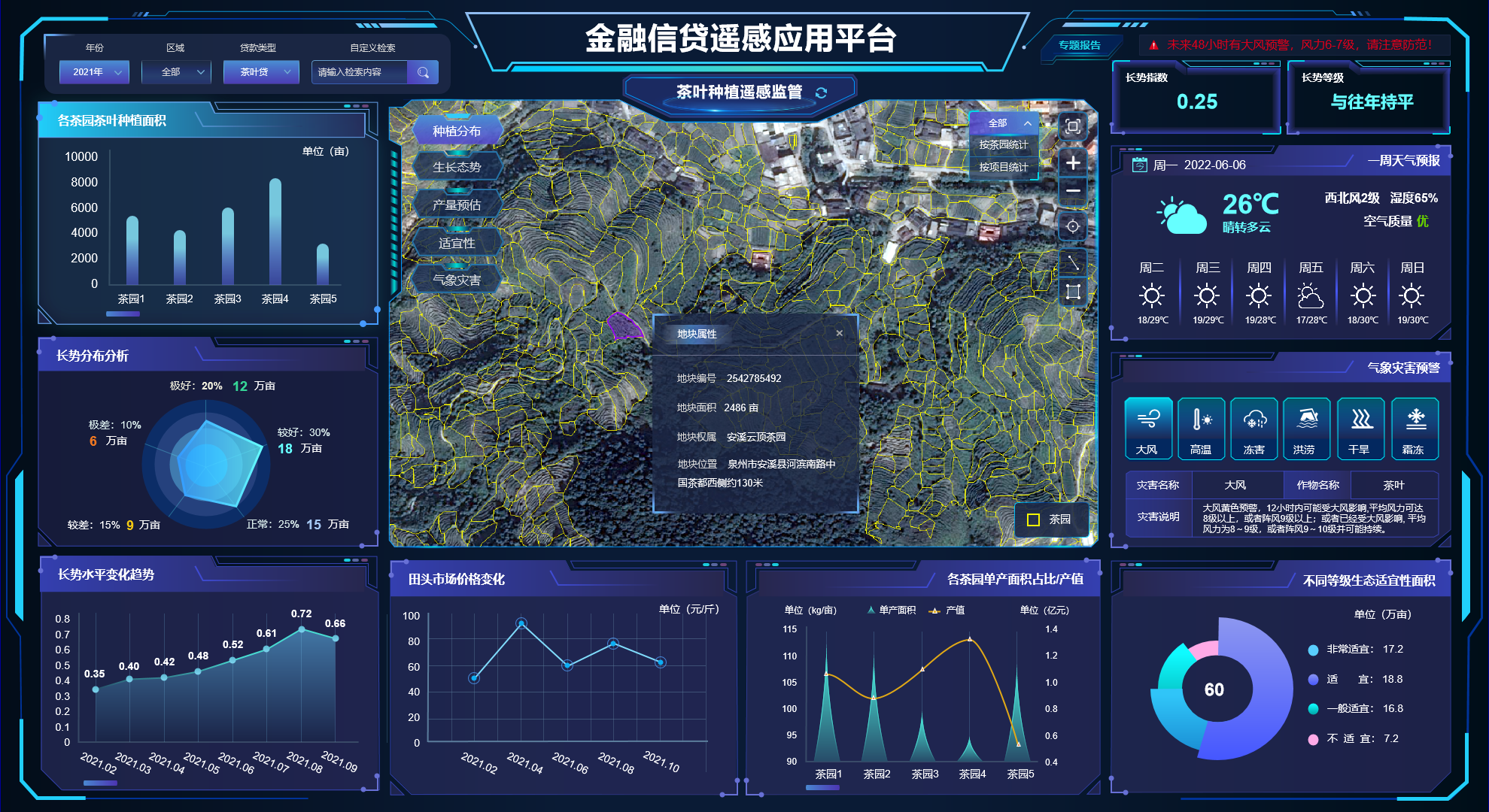
Application in Agricultural Loans
In agricultural and forestry loans, our AI-powered arable land parcels detection algorithm provides reliable data to financial institutions for assessing eligibility, calculating loan amounts and monitoring risks.
In agricultural and forestry loans, our AI-powered arable land parcels detection algorithm provides reliable data to financial institutions for assessing eligibility, calculating loan amounts and monitoring risks.
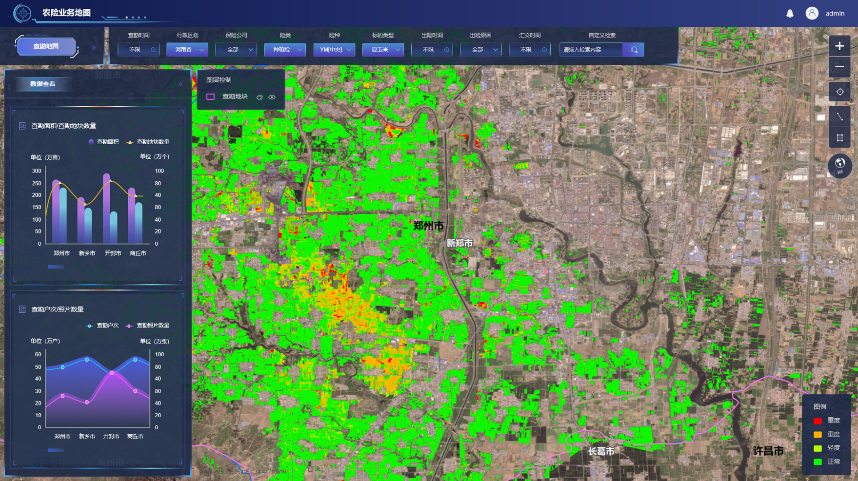
Agricultural Insurance Applications
With the advancements in AI technology for geospatial analytics, we can now automate the extraction of data of arable land parcels, crop distribution, growth status, greenhouse locations, disaster conditions, etc. This optimization effectively streamlines the inspection and investigation process for agricultural insurance companies.
With the advancements in AI technology for geospatial analytics, we can now automate the extraction of data of arable land parcels, crop distribution, growth status, greenhouse locations, disaster conditions, etc. This optimization effectively streamlines the inspection and investigation process for agricultural insurance companies.
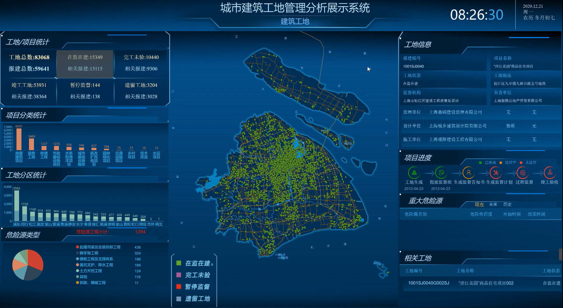
Urban Construction Site Management and Analysis
Our technology enables the monitoring and analysis of city-wide construction projects. Analytic results include construction site distributions, work zone types and statistics, on-site hazard control, construction progress, year-on-year site location comparisons, as well as identification of abandoned construction site.
Our technology enables the monitoring and analysis of city-wide construction projects. Analytic results include construction site distributions, work zone types and statistics, on-site hazard control, construction progress, year-on-year site location comparisons, as well as identification of abandoned construction site.
All Products